

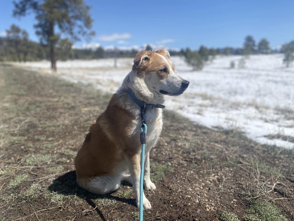
Mama Mia is a sweet, Humane Society pup & is available for foster or adoption. She is a 2 year-old, 40lb Border Collie mix that is ready to be someone’s hiking buddy! Huge thanks to Miss Ruby for getting her out for a Riverside walk this morning. Scroll to end to see more images of Mama Mia and also Bonnie & Smiley.
Today was a nice break after a windy Saturday in which we had snowshowers in & out all day!
If images fail to load in the email, just click the title of the post.
Sunday – 7 Apr 2024 – 6:00pm
Storm Wrap Up…
At Stevens Field the high temperature yesterday afternoon was 32 (!) and the low this morning was 14. Mark in the Reserve was the cold spot at 6 degrees. This equaled the airfield record low temperature for the day!
The peak wind at the airfield yesterday afternoon was 40mph!
| Average High | Record High / Year | Average Low | Record Low / Year |
| 57 | 74/ 1991 | 23 | 6 / 1979 |
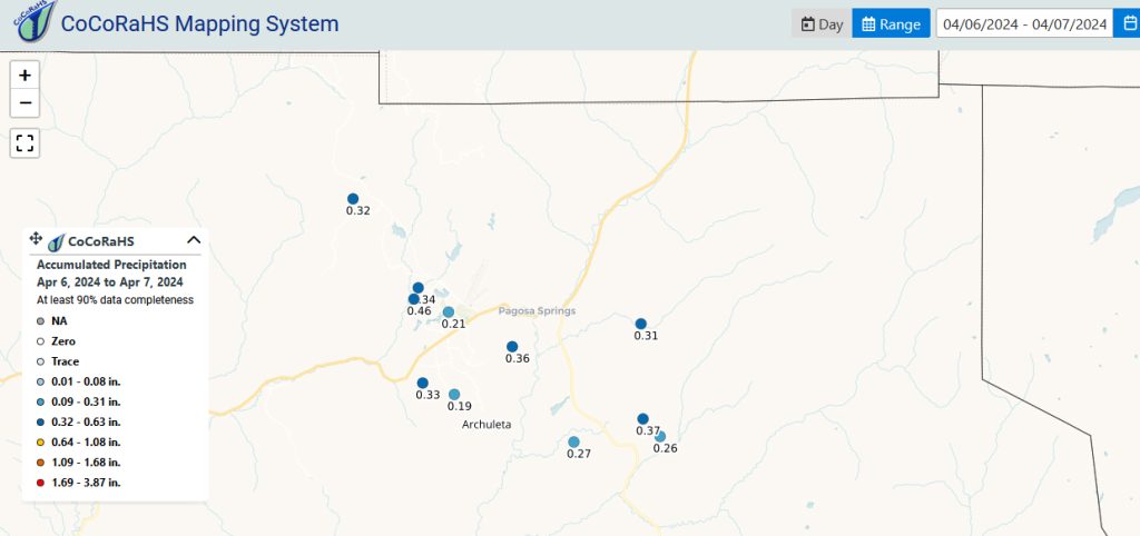
Precipitation summary… We had snowshowers and snow pellets move in and out of the area yesterday afternoon. Thunderstorms stayed to our west. Reports this morning had a tract to.04″ of liquid and a trace to .5″ of snow. Wolf Creek reported 5″ of new snow for a storm total of 13″ and a season total to 325″.
CoCoRaHS maps below are for the 2 day storm total.

Forecast discussion…
Satellite…

Area of low pressure and associated fronts have ejected off to the northeast. A weak area of low pressure is forming to our west but will sink to the south of us. Otherwise it is all high pressure and fair weather to the west moving our way.
Radar… We do not have any precipitation in our area at this time.
Forecast highlights…
*** Spring weather returns this week ***
Sunday – A Nice Break in the action!
Sunday started out COLD but otherwise will be partly to mostly cloudy with some increasing clouds late in the day.
Winds… Winds will switch back to the southwest and be breezy in the afternoon with gusts of 20-25mph in the valley areas and 25 to 30mph in the mountains in the afternoon.
Temps… Highs on Sunday will be lo-40s to hi-40s.
Monday: Eclipse
A lot of friends and neighbors are traveling to see the Total Solar Eclipse tomorrow. The sun will slip behind the moon from about 12:40 MT to 14:30 MT. We’ll only be in about 65% of the eclipse but we might notice that it is not as bright and we could see the temperature drop a few degrees.

Unfortunately, that weak area of low pressure sinking into southern New Mexico is going to wrap moisture in from the Baja area and there will clouds along much of the eclipse path.

Monday & Tuesday – A Weak “Disturbance”
A weak disturbance approaches us from the west and sinks to our south and forms an area of low pressure. We’ll be mostly cloudy with some snowshowers over our mountains and some wind. Otherwise all of the storm energy will be well to our south. Most models agree with this solution.
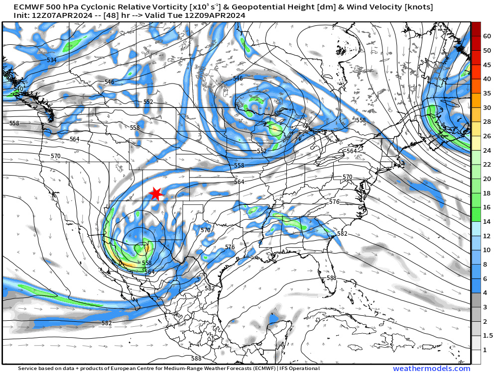
500MB Valid for Tuesday 9 April at 06am. 500MB is equal to ~ 18,000 feet in the atmosphere. We analyze this level for big picture features. This is a vorticity chart which shows where the spinning or energy is at in the horizontal. On Tuesday morning it will be to our south as depicted by the blue/green/orange colors.
Snow Levels: Increase to 4,800′ early Monday and to 8,700′ by Tuesday evening. Our airmass will be modifying.
Precipitation and Snow amounts: The mountains could see a trace to 4″ of snow overnight Monday to Tuesday evening.

Winds… Occasional gusts to 18mph in the afternoon in the valley. Mountains could see 25mph.
Temps… Low temps on Monday lo-20s. Highs on Monday will be in the lo-40s to hi-40s.
Low Temps on Tuesday will be in mid to hi-20s. High temps on Tuesday will recover to the low 50s to the mid-50s.
Wednesday through Friday – Spring Returns!
Spring will return to Pagosa Country starting on Wednesday! We’ll have partly cloudy to clear skies and sunny days that will quickly warm up!
Winds… We might see a gust to 18mph in the afternoon.
Temps… Low temps will start out on Wednesday in the mid 20s and modify to lo- to mid-30s by Friday morning. Hi temps will start out on Tuesday in the mid 50s and will soar to the mid-60s by Friday!

500MB Valid for Thursday 11 April at 6pm. 500MB is equal to ~ 18,000 feet in the atmosphere. We analyze this level for big picture features. The orange colors indicate areas of high pressure or good weather and blues areas of low pressure or bad weather (some might consider that “good”!). In this case on Thursday we are under a “Big Bubble, No Trouble Dome”.
Wolf Creek Ski Resort
Wolf Creek has announced on their web page that today was their last day of operations. See you next winter!
Pagosa Spring Humane Society
We have no-kill Humane Society right here in Pagosa Springs. Shawn and I volunteer and walk dogs there every Sunday. Today was one of the most pleasant days of the year so far!
Here are a few more images of my favorite gal, Mama Mia. She is sweet, reserved, and very smart. She is a pleasure to walk! She is only 2 years old and a nice compact 40 pounds. She is either a border collie mix or Australian Keltie. Huge thanks to Miss Ruby for taking her down to the river walk this morning.



I walked Miss Bonnie and Mr. Smiley this morning. Both were a joy to walk.
Sadly, Miss Bonnie’s owner passed away. She is a very, very sweet Australian shepherd who is about 5 years old and is very well mannered and very smart. Go visit her at the Humane Society and she will immediately draw you in with a pair of soulful eyes and an outreached paw.
Mr. Smiley, a young cattle dog, is high energy and revved to go on any adventure. Still, he is easy to walk and responds quickly to his name with immediate eye contact. Especially, if he knows he’ll be rewarded with a treat!

We could see some April showers next weekend. Shawn will have all the details in your next weather post on Tuesday! We’ll be out fishing tomorrow.
– Arleen


One Response
Thank you so much, Arlene, for featuring our awesome dogs! If anyone out there is interested in any one of these wonderful dogs, please let Arlene or Ruby know. We will make sure you are able to meet them.