It’s will get worse before it gets better…

There is a FLOOD WATCH  in effect through Tuesday evening. Forecast models expect another 2” to 2.5” of rain in the Pagosa area and up to 4” in our mountains. Note the high amounts across northern NM and southeast CO. There will be flooding and travel problems across much of the region.

There is a FLOOD WATCH  in effect through Tuesday evening. Forecast models expect another 2” to 2.5” of rain in the Pagosa area and up to 4” in our mountains. Note the high amounts across northern NM and southeast CO. There will be flooding and travel problems across much of the region.

Monday – 28 Sep 2026 – 3:00pm

The past…

Stevens Field Observations

Saturday: High: 70, Low: 38, Peak wind: 9mph, Afternoon humidity: 35-40%

Sunday: High: 71, Low: 43, Peak wind: 17mph, Afternoon humidity: 26-31%

Average HighRecord High / YearAverage LowRecord Low / Year
7083 / 19573320 / 1908

Precipitation summary… It was dry through most of the weekend, and then light rain began to fall on parts of the county around sunrise on Monday.

CoCoRaHS 24-hour rain observations across Archuleta County reported Monday morning ranged from 0.02” to 0.15”.

Current satellite and radar…

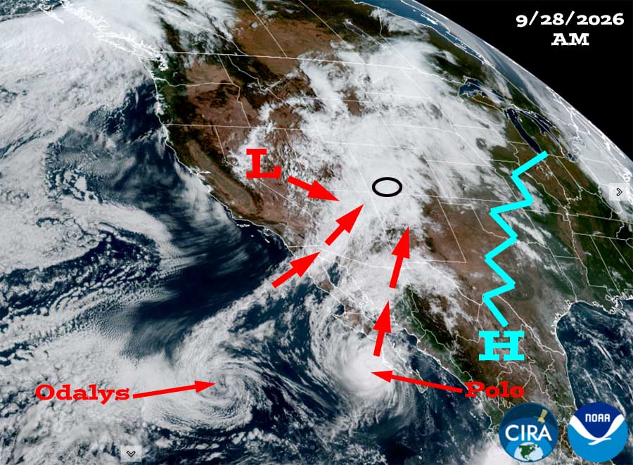
Visual satellite Monday morning – Southerly flow between the ridge to our east and the low over NV is funneling tropical moisture into the Four Corners region from Odalys and Polo.
Radar at 2:34pm Monday – These bands of rain are impressive extending from northern Mexico into northeast CO. The band over us now will move east early Tuesday morning. We’ll have a lull with hit and miss showers Tuesday around sunrise into early Tuesday afternoon and then another band of heavier precip will move over us.
Archuleta County is circled in black.

Forecast highlights…

*** There is a FLOOD WATCH in effect through Tuesday evening. This could be extended into Wednesday afternoon. ***

*** Through Wednesday evening will be wet as the remnants of hurricane Polo visits. There will be periods of moderate to heavy rain. ***

*** Then it looks like it will be mostly sunny and dry for a while. ***

Rest of Monday into Wednesday evening… A low currently over southern NV will move through central AZ and NM, and then into southeast CO. At the same time, remnants of hurricane Polo will get wrapped into the low and give us a good soaking.

Timing… Steady rain, occasionally heavy, will fall into early Tuesday morning. There will be a lull with hit and miss showers sunrise Tuesday into early Tuesday afternoon, and then precip will ramp up again late Tuesday afternoon into Wednesday afternoon. Showers will taper off Wednesday evening.

I’m not a hydrologist, but I think the San Juan and Piedra rivers will crest in the 2,400cfs to 2,800cfs range sometime on Tuesday. This is below “minor flood” stage. However, flood prone areas will have problems into Wednesday evening. There’s also a good chance for rockslides and debris on roads.

And what about SNOW?  The snow level will be 12,500ft to 13,000ft for much of this event. By sunrise Wednesday, it will be around 12,000ft.

Our mountains above 12,000ft will get 1-3” of snow. The Wolf Creek ridge and Alberta could get a dusting.

Wednesday night and Thursday… The low will slowly move through southeast Colorado. We will dry out, but southeast Colorado could get 2.5” to 3.5” of rain. This will cause areas of flooding and sketchy travel conditions.

*** If you plan to drive through northeast NM or southeast CO, keep an eye on the weather and travel conditions. ***

*** There will be patchy fog and low visibility in our area Wednesday night into Thursday morning. ***

Friday through next Monday… A Rex block will set up between a tropical system spinning south of Cabo and a high over the desert southwest. We will have lots of sun and temps near average.

Temps…

Monday night lows will be in the low to mid 40s.

Tuesday and Wednesday highs will be in the low to high 50s.  Tuesday night lows will be in the mid 40s to near 50. Wednesday night lows will be in mid 30s to the low 40s.

Thursday and Friday highs will be in the mid 60s to the low 70s and lows will be in the mid 30s to the low 40s. *** The cold spots will flirt with freezing temps. ***

Saturday, Sunday, and next Monday highs will be in the high 60s to the mid 70s and lows will be in the mid 30s to low 40s.

Winds…

Each afternoon gusts will be 15-20mph.

*** As always, isolated stronger gusts are likely near showers and thunderstorms. ***

WPC precip from noon Monday to late Wednesday evening shows 2.44” in the Pagosa area and up to 4” in our mountains.

5 Oct to 13 Oct… A Rex block will likely keep us mostly dry and mild during this period.

Euro ensemble total precip to 13 Oct shows 3.18” in the Pagosa area. Most of this precip is between now and Wednesday evening.
Euro ensemble total snow to 13 Oct shows 3-6” near Wolf Creek and up to 12” on our higher peaks.
This is Euro ensemble 24-hour and total precip amounts for the Pagosa Springs area to 13 Oct. It’s read left to right, and times are in Zulu. The top chart shows 24-hour precip amounts for 50 versions of the Euro forecast model. The bottom chart graphs the control, mean, and range of the 50 versions. It’s wet into Wednesday evening and then it’s not wet the rest of the period.
This is Euro ensemble 24-hour and total precip amounts for the Pagosa Springs area to 13 Oct. It’s read left to right, and times are in Zulu. The top chart shows 24-hour precip amounts for 50 versions of the Euro forecast model. The bottom chart graphs the control, mean, and range of the 50 versions.
It’s wet into Wednesday evening and then it’s not wet the rest of the period.

The next post will be on Wednesday.

– Shawn

Pagosa Weather Blizzard Level Sponsor

Pagosa Weather Storm Sponsor

Picture of Shawn Pro

Shawn Pro

I’ve been a “weather geek” since I was young child. I joined the military out of high school and was lucky to get my dream job in weather. I have 20 years of military weather experience which includes forecasting the weather all over the world. Highlights were six years in Alaska and making life and death weather decisions during deployments. I love mountains, I love snow, and I love summertime thunderstorms. I spend a bunch of time playing outdoors and found my paradise in Pagosa Springs. I do Pagosa Weather as a community service. Hopefully you find us helpful!

Leave a Reply

Your email address will not be published. Required fields are marked *

Pagosa Weather Disclaimer and Release of Liability

This website makes no guarantees about nor bears any responsibility or liability concerning the accuracy or timeliness of the weather information published on this website. All weather information published on this website is for educational and weather enthusiast purposes only. We do not issue Storm Watches, Warnings or Advisories as that ability falls with the National Weather Service, who is the only institution allowed to issue such warnings by law. We are not in any way linked nor affiliated with the National Weather Service, although we do share information and relay weather watches/ warnings, etc. Use of the information on page is at your own risk/discretion, and we are not responsible for any personal/property damages, injury or death associated with weather forecasts, reports or other information as well as communication exchanged in private messages and/or person.

Terms of Use                  Privacy Policy

© 2026 Pagosa Weather 

Website Design by : Brandon