

High above highway 24 near Woodland Park – pic taken 5/2/2026
Sunday – 3 May 2026 – 2:45pm
The past…
Stevens Field Observations
Friday: High: 54, Low: 30, Peak wind: 25mph
Saturday: High: 62, Low: 25, Peak wind: 21mph
| Average High | Record High / Year | Average Low | Record Low / Year |
| 64 | 85 / 1947 | 27 | 14 / 1951 |
Precipitation summary… We got a little precip on Friday. I estimate that the Wolf Creek area got 1-3” of snow.
CoCoRaHS 24-hour precip yesterday (2 May) ranged from zero to 0.16”.
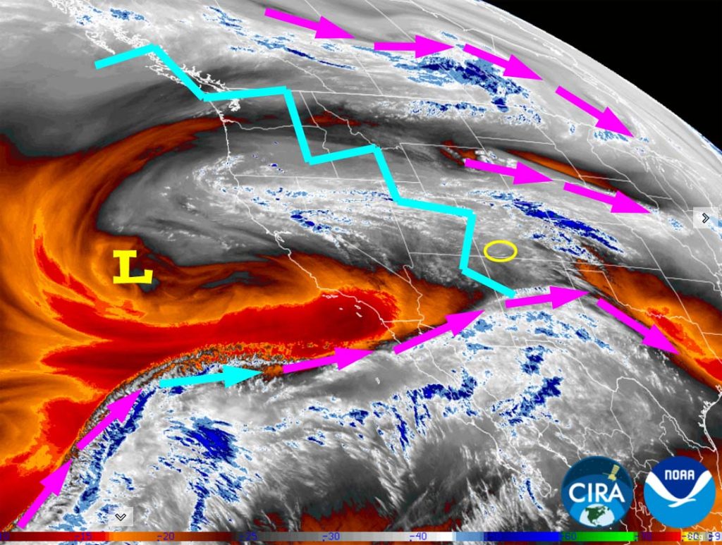
Current satellite and radar…

Forecast highlights…
*** Spotty light showers are possible Sunday and Monday afternoons, but most of us will stay dry. ***
*** We will get a little precip Tuesday afternoon into Wednesday evening. ***
*** Hard freeze possible Wednesday night. ***
*** Thursday through next weekend there will be lots of sun and pleasant temps. ***
Forecast details…
Rest of Sunday through Tuesday morning… A weak ridge will be in the area through Monday morning, and then upper-level southwest flow will gradually increase ahead of the next storm.
There’s a little moisture and a little instability, so there’s a chance for a spotty afternoon shower or thunderstorm, mostly over the mountains.
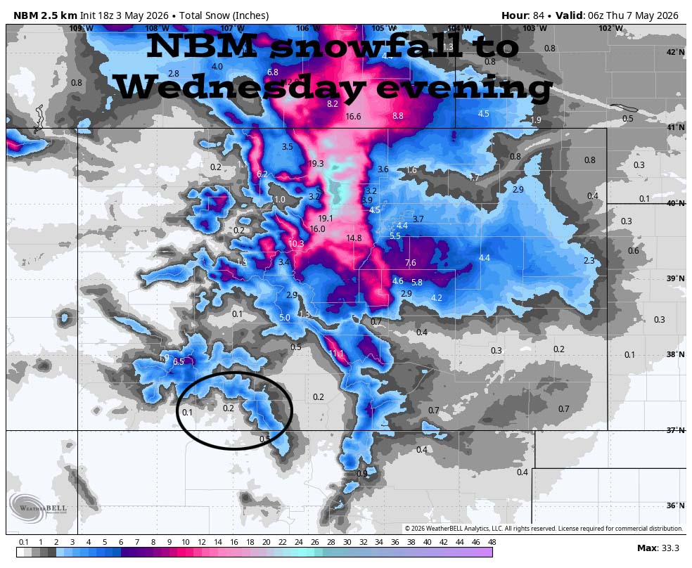
Tuesday afternoon into Wednesday evening… A low-pressure system will move through southern AZ and NM while a trough moves through our area from the north. Moisture and instability will increase so we’ll see scattered showers and a thunderstorm or two. Precip amounts will be light and spotty.
Snow levels on Tuesday will be above 9,000ft and then drop to around 8,000ft Tuesday night. By Wednesday afternoon snow levels will climb back up to 9,000ft.
Precip forecast…
Mountains above 9,000ft: 2-4”
Pagos Springs area: 0.05” to 0.25”
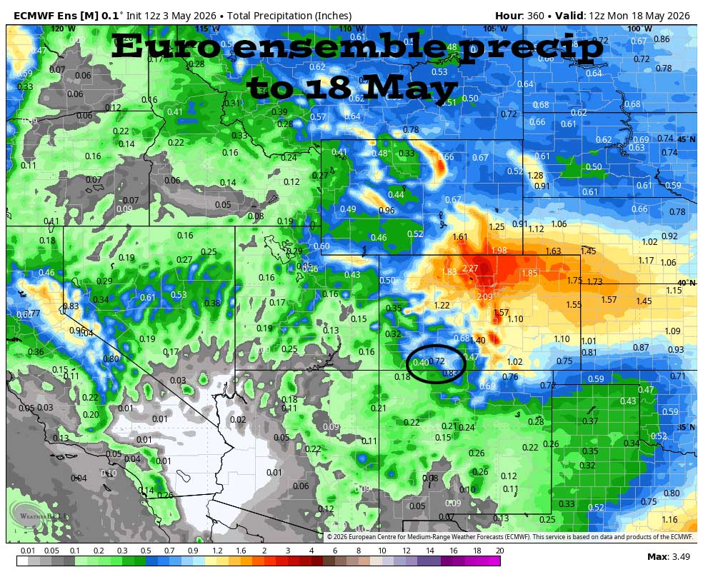
Wednesday night through next weekend… I expect most of this period to be dry, but there’s a slight chance for a few spotty showers next weekend, mostly over the mountains.
Temps…
Sunday night lows will be in the low to high 30s.
Monday highs will be near 60 to the high 60s and lows will be in the high 20s to the mid 30s.
Tuesday highs will be in the mid 50s to the mid 60s. Tuesday night lows will be in the low to high 30s.
Wednesday highs will be in the high 40s to the mid 50s and lows will be in the low to high 20s.
Thursday highs will be mid 60s to the low 70s and lows will be in the high 20s to the mid 30s.
Friday, Saturday, and next Sunday highs will be in the high 60s to the mid 70s and lows will be in the low to high 30s.
Winds…
Monday afternoon gusts will be 25-30mph in the Pagosa area and 40-45mph in the high country.
Tuesday afternoon gusts will be around 25mph in the Pagosa area and 30-40mph in the high country.
Wednesday through next weekend, each afternoon gusts will be 15-20mph in the Pagosa area and 25-35mph in the high country.

Northeastern CO will be favored.
10 May to 18 May… The forecast models are starting to agree that the weather pattern will dry out for us.
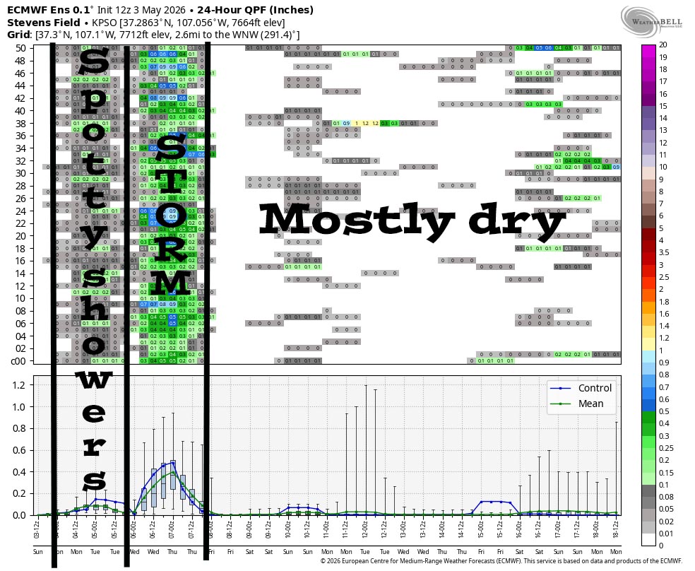
There’s a chance for spotty light showers through Monday afternoon. Things look good for a weak storm Tuesday afternoon into Wednesday evening. The rest of the period is trying to dry out.
The next post will be Tuesday afternoon.
– Shawn


