Pagosa Weather MARCH SUMMARY & April Outlook

Snowpack is rough in southwest Colorado and worse for AZ and NM

Snowpack is low in southwest Colorado and worse for AZ and NM

Thursday – 3 Mar 2025 – 11am

March Summary…

The average high for March is 49 and the average low is 15. The record high of 73 occurred on 19 March 1907. The record low of -25 occurred on 1 March 1913. March precip averages 1.77″ and average snowfall is 15.1″. Wolf Creek Pass averages 4.90″ of precip and 75.8″ snow.

At Stevens Field the highest temp was 68 on 25 Mar and the lowest temp was 10 on 16 and 20 Mar. There were 5 days with winds over 30mph. The strongest wind was 52mph on 6 Mar.

How did we do?

March mean temperature anomalies across much of Archuleta County were 1-3 degrees above average.
March mean precip anomalies were 50-60% of average for most of Archuleta County.

CoCoRaHS precip totals ranged from 0.72″ to 1.86″. Just one location was near the average of 1.77″.

Total precip for 2024 is 2.45″ – 42% of the average of 5.87" for this point of the year
Total precip for 2024 is 2.45″ – 42% of the average of 5.87″ for this point of the year

CoCoRaHS snow totals ranged from 6.2″ to 15.7″. Just two locations were near the average of 15.1″.

We’ve received 33″ of snowfall so far this winter – just 35% of the average of 94.8″

Wolf Creek Ski Area got 62″ of snow in March – 82% of average.
For the season 202″ has fallen – 53% of average
Wolf Creek Ski Area got 62″ of snow in March – 82% of average.
For the season 202″ has fallen – 53% of average

Snowpack and Drought…
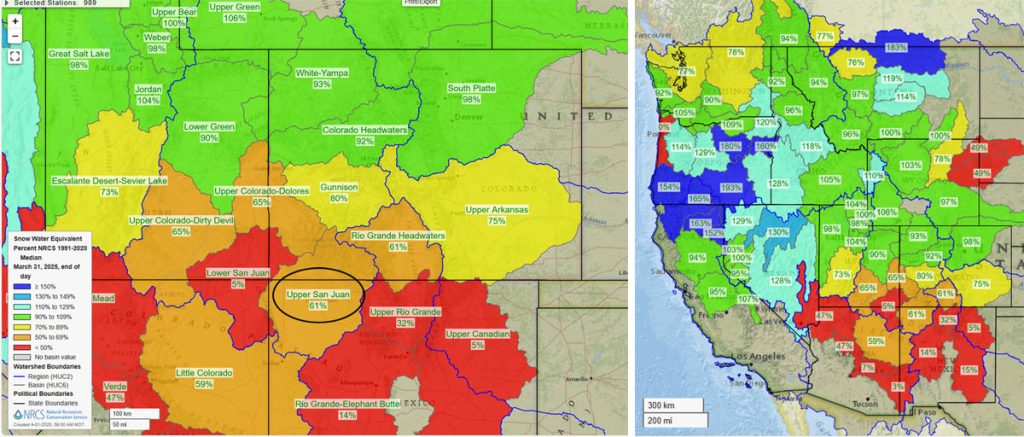
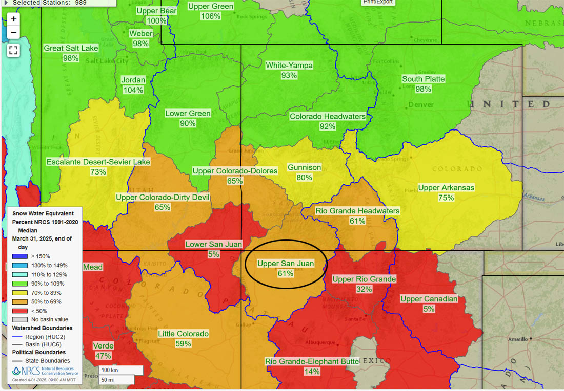
Current snowpack percent of median.
The Upper San Juan snotel is at 41% of the seasonal median and the Wolf Creek Summit snotel is at 59%
Current snowpack percent of median.
The Upper San Juan snotel is at 41% of the seasonal median and the Wolf Creek Summit snotel is at 59%
Archuleta County has “severe drought” conditions and our San Juan Mountains have "extreme drought" conditions.
The US drought map on the bottom shows that much of the country is experiencing drought conditions.
Archuleta County has “severe drought” conditions and our San Juan Mountains have “extreme drought” conditions.
The US drought map on the bottom shows that much of the country is experiencing drought conditions.

April Outlook…

The average high for April is 59 and the average low is 24. The record high of 81 occurred on 30 April 1981. The record low of -4 occurred on 1 April 1980. April precip averages 1.38″ and average snowfall is 5.5″. Wolf Creek Pass averages 3.42″ of precip and 44.8″ snow.

The CPC temp outlook for April on the left shows a 50-60% chance for above average temps.
The precip outlook on the right shows a 33-40% chance for below average precip.
The CPC temp outlook for April on the left shows a 50-60% chance for above average temps.
The precip outlook on the right shows a 33-40% chance for below average precip.
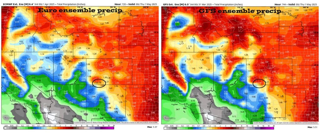
Euro ensemble precip on the left expects 1.79″ of precip for April and the GFS ensemble precip on the right expects 2.16″ – Both models expect more than the average of 1.38″.

And what do we expect?

Arleen is the expert, and this is what she says…

Arleen Prochazka

April showers bring… that is not necessarily the truth for our area as April is our 3rd driest month. It is still transition season with a high of 70 one day & a low of 5 the next day; whiplash weather!

We’ll have unsettled weather at the beginning of the month, some mid month & a little at the end of the month. But it won’t be enough to get us up to average. The GFS & Euro are indicating above average but they were too high last month so verification is poor. CPC is indicating less than average & it verified well last month. So we’ll have less precipitation than average with a warmer than average month.

A HUGE thanks for your precip reports and pictures! Reports help verify our forecasts and make us better forecasters.

Another HUGE thanks to our donors and sponsors! You help cover the cost of this web page and our weather subscriptions, necessary to provide you accurate weather reports!

  • Shawn

Pagosa Weather Blizzard Level Sponsor

Pagosa Weather Storm Sponsor

Picture of Shawn Pro

Shawn Pro

I’ve been a “weather geek” since I was young child. I joined the military out of high school and was lucky to get my dream job in weather. I have 20 years of military weather experience which includes forecasting the weather all over the world. Highlights were six years in Alaska and making life and death weather decisions during deployments. I love mountains, I love snow, and I love summertime thunderstorms. I spend a bunch of time playing outdoors and found my paradise in Pagosa Springs. I do Pagosa Weather as a community service. Hopefully you find us helpful!

2 Responses

  1. Is it possible to be able to set up a recurring donation via internet. I try to contribute monthly via credit card through square but getting old and forgetful I would like to set up a recurring donation, set it and forget it. Any comment on this?

    Thanks
    Ernie OToole

Leave a Reply

Your email address will not be published. Required fields are marked *

Pagosa Weather Disclaimer and Release of Liability

This website makes no guarantees about nor bears any responsibility or liability concerning the accuracy or timeliness of the weather information published on this website. All weather information published on this website is for educational and weather enthusiast purposes only. We do not issue Storm Watches, Warnings or Advisories as that ability falls with the National Weather Service, who is the only institution allowed to issue such warnings by law. We are not in any way linked nor affiliated with the National Weather Service, although we do share information and relay weather watches/ warnings, etc. Use of the information on page is at your own risk/discretion, and we are not responsible for any personal/property damages, injury or death associated with weather forecasts, reports or other information as well as communication exchanged in private messages and/or person.

Terms of Use                  Privacy Policy

© 2026 Pagosa Weather 

Website Design by : Brandon