

Low stratus clouds about 200ft above the windmill. – Pic taken 3 Feb 2024 at 8am
If images fail to load in the email, please click the title of the post. Thanks!
Saturday – 3 Feb 2024 – 11:45am
The past…
At Stevens Field the high temperature yesterday afternoon was 35 and the low this morning was 28.
The peak wind at Stevens Field yesterday afternoon was 16mph.
| Average High | Record High / Year | Average Low | Record Low / Year |
| 40 | 54 / 1991 | 3 | -22 / 1914 |
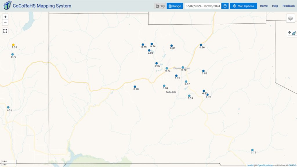
Precipitation summary… It snowed much of yesterday but temps above freezing made it difficult for snow to accumulate. Most locations got 2-4” of snow.
Wolf Creek reported 10” of new snow in the last 24 hours and 15” for the storm.

Forecast discussion…

Forecast Highlights…
*** Spotty snowshowers today – not much accumulation expected. ***
*** The WINTER STORM WARNING for the southwest San Juan Mountains will expire at 5pm Saturday. *** This does not include Pagosa Springs.
*** Avalanche danger is rated “considerable”. ***
*** Next storm Tuesday afternoon to Thursday morning. ***
*** The third, and possible final, storm is Friday and Saturday. ***

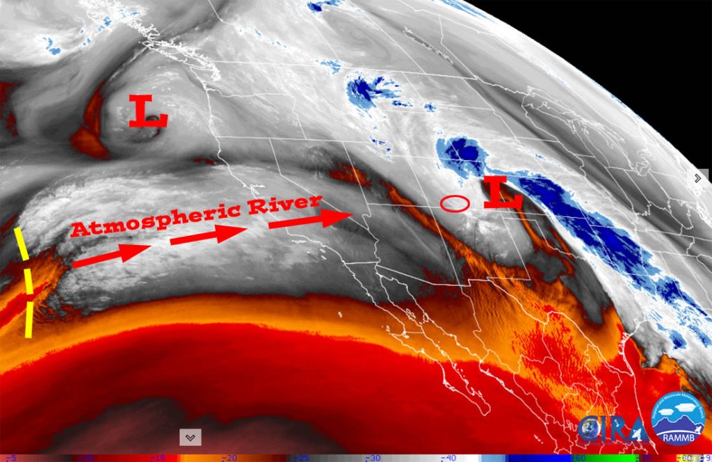
Rest of Saturday… The upper-level low will spin near the TX panhandle and wrap moisture into CO. This pattern favors the Front Range, not us. A spotty snowshower is possible in the valley, more likely towards the Chromo and Chama areas. Wolf Creek will see light snow most of the day.
Patchy fog is possible in the low-lying areas tomorrow morning.
Snow amounts…
Valley: a dusting in a few lucky spots
Mountains: 1-3”
Winds… Peaks will be around 15mph.
Temps… Highs Saturday will be in the low to high 30s and lows Saturday night will be in the low teens to low 20s.
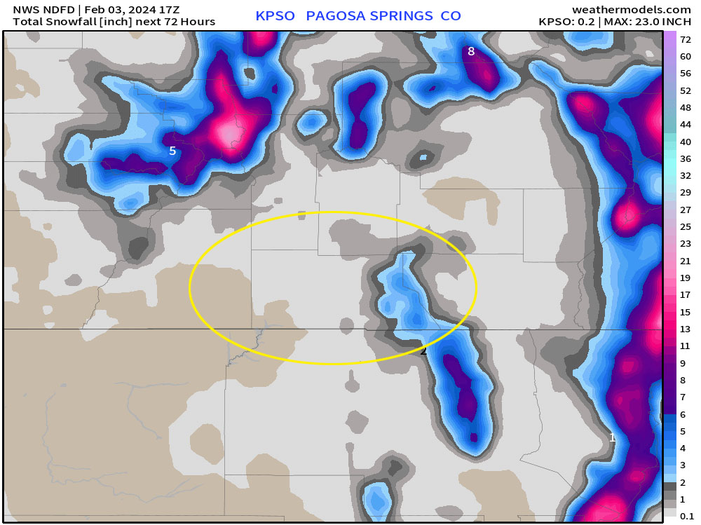

Sunday through Tuesday morning… Transient ridging will keep us dry. Clouds will increase Monday afternoon as the ridge moves to our east. A few spotty snowshowers are possible over the mountain Tuesday morning, but snow accumulation will be minimal.
Winds… Peaks will be around 10mph each afternoon.
Temps… Highs on Sunday will be in the mid-30s to low 40s and lows Sunday night will in the low teens to low 20s. Highs on Monday will be in the low to high 40s and lows Monday night will be in the mid-teens to mid-20s.
Tuesday afternoon into Thursday morning – I like how this system is lining up – jetstream support, storm energy, moisture, precipitable water, and flow look good. With a long southerly fetch, it will start off a little warm like the system that just moved through but will cool more quickly and give us a longer period for snow to accumulate.
Timing… The first scattered showers will start over the mountains Tuesday morning and over the valley Tuesday afternoon. The heaviest precip will fall Tuesday evening into Wednesday afternoon. Precip will become more showery Wednesday evening through Thursday morning.
Snow levels… Will start around 8,000ft Tuesday afternoon, drop to 7,000ft by sunrise Wednesday, bounce around between 6,500ft and 7,000ft until sunset Wednesday, and then stay below 6,500ft the rest of the period.
Snow amounts…
Valley below 7,400ft: 3-6”
Valley above 7,400ft: 6-10”
Mountains: 20-30”
Winds… Peaks will be around 20mph each day.
Temps. Highs Tuesday will be in the high 30s to mid-40s and low Tuesday night will be in the low to mid-30s. Highs Wednesday will be in the mid to high 30s and lows will be in the low to high 20s. Highs Thursday will be near 30 to the mid-30s.

My thoughts… These totals are a bit high in the valley due to temps at and above freezing during the beginning of this system. It looks reasonable for the mountains, but other models have a little less so I’m leaning towards slightly lower amounts at this point.
My next post will be Monday morning. I hope to finish the January summary/February outlook later today.
– Shawn


